
The Sleeping Giant
 Twitter
 Facebook
 Forward
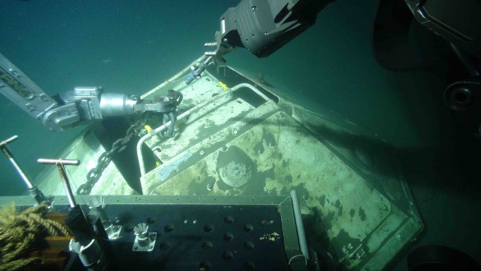
“Like threading a needle with boxing gloves on”—in this underwater image shot from “Jason,” a remotely operated vehicle, an operator on the Atlantis research vessel maneuvers manipulator arms to prepare to lift an ocean-bottom seismometer. Watch a video of Jason in action.
Off the coast of the Pacific Northwest, a giant sleeps.
It lies along the trench where the North American continent is colliding with the Juan de Fuca plate. Along the 700-mile stretch where these earthen masses meet and the Juan de Fuca plate is being pushed under the West Coast, pressure is building. When this area breaks—and it will—the region could experience a magnitude 9 earthquake and tsunami on the order of those that devastated South Asia in 2004 and Japan in 2011.
No one knows the exact characteristics of this “locked zone” called Cascadia. But University of Oregon geophysicists Doug Toomey, Emilie Hooft and Dean Livelybrooks intend to find out. With funding from the White House itself, these UO researchers are part of a national effort to study this zone, to determine its size and shape and to learn how this volatile area will behave when it eventually buckles.
To put a face on the giant, so to speak, before it rises up.
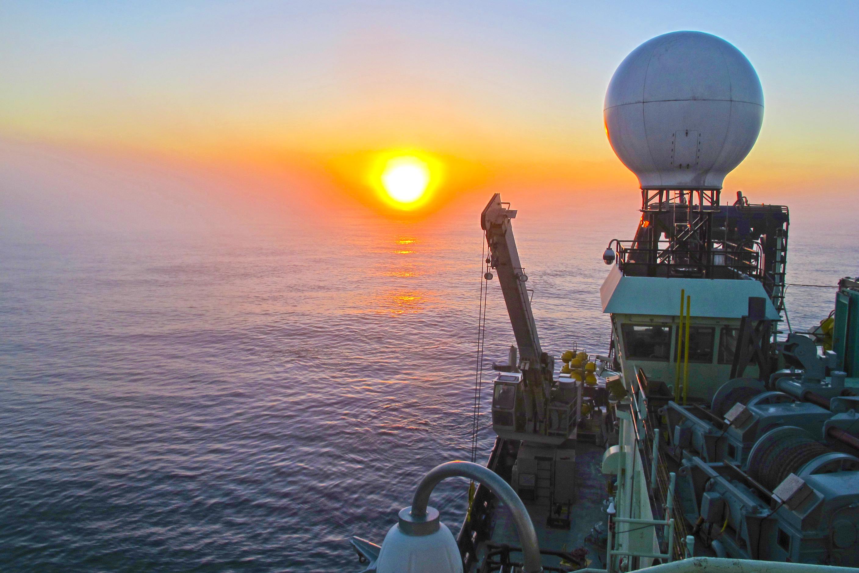
Sunrise from the research vessel Atlantis.
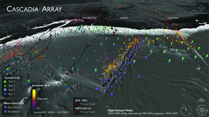
Toomey is leading the expedition team for the Cascadia Initiative, a four-year, $30 million project funded by the National Science Foundation that features the largest array of offshore earthquake-measuring instruments in history. Hundreds of seismometers are recording vibrations on the ocean floor from the Canadian border to Northern California, including—for the first time—the recording of tremors in shallow water, a critical area that has historically been too difficult to monitor due to the operation of fisheries.
Around the world, wherever tectonic plates collide, there are unstable subduction zones—areas where immense amounts of energy are stored as one tectonic plate is pushed under another or “subducted.”
“The project will tell how Cascadia is locked along the coastal area,” Toomey said. “The extent to which the locked zone does or does not go onshore dictates the intensity of shaking in that region. It is this intensity that knocks down structures, so knowing how far Seattle or Portland or Eugene are from the locked zone helps estimate risk.”
Averting Disaster
It’s imperative to get a better understanding of the likely effects of a major earthquake and tsunami because the Pacific Northwest is ill-prepared for such an event. A state commission on seismic safety and policy reported to the legislature last February that Oregon is “far from resilient” to the impacts of a magnitude 9 earthquake.
Without improvements, fatalities are estimated at 1,250 to more than 10,000, with tens of thousands of buildings destroyed or extensively damaged and tens of thousands of households displaced. There would be $30 billion in direct and indirect economic losses, close to one-fifth of Oregon’s gross state product.
The NSF is funding the Cascadia Initiative in part with $10 million from the American Recovery and Reinvestment Act for “research to avert disaster . . . and understand the threats posed in this important region,” as stated in White House literature describing 100 projects supported under the 2009 economic stimulus package.
A specialist in the seismic structure of plate boundaries, Toomey is overseeing a national group of scientists who are deploying and recovering ocean-bottom seismometers and developing education and outreach programs over the four-year period ending in 2015.
He was chosen for the role not just because of his background and his close proximity to the Cascadia subduction zone, but because he has an excellent command of both the big picture and the details necessary to carry it out, NSF officials said. Toomey has been involved with the initiative since its inception, proposing adjustments such as the use of less-expensive temporary seismic stations to keep the project on track.
“Doug stepped forward and made the case to parts of the NSF that this really should go forward,” said Donna Blackman, a program director with the foundation’s Division of Ocean Sciences. “Lots of other scientists in the community agreed with the high priority of this science and societal implications.”
Find and Retrieve
“Jason going over the side. Enable thrusters.”
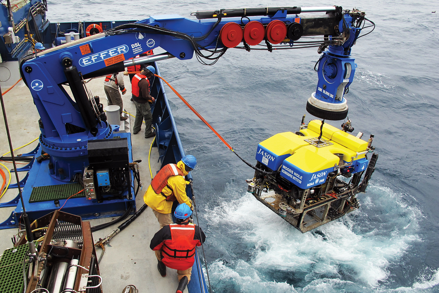
Jason, a remotely operated vehicle used to retrieve seismometers, is lifted onto Atlantis.
The order came from a pilot onboard the Atlantis research vessel—and with it, a boxy, remotely operated vehicle (ROV) about the size of a Mini Cooper—dubbed “Jason”— was lowered into the Pacific Ocean and began scouring its depths, tethered to the ship by a six-mile fiber optic cable that delivers electrical power and commands.
Its mission: Find and retrieve seismometers from the ocean floor.
This operation was repeated many times over during a voyage last summer by a Cascadia Initiative research team that included UO geophysicist Dean Livelybrooks.
During a two-week trip with more than a few ups and downs—read: unusually rough waters—the “Jason dives” were featured attractions for scientists and ship crew alike.
For the uninitiated, life at sea is a study in contrasts: the excitement and anxiety of setting sail, coupled with the boredom of long hours when there is nothing to do; the steady metronome of mealtime (7:30 a.m., 11:30 a.m., 5:30 p.m.), offset by the crew’s odd hours (shifts starting at 4:00 p.m., 8:00 p.m. or even midnight); the absence of visible land for days on end, at once both exhilarating and unsettling.
Marine life provided rich experiences for first-time sailors on Atlantis. A starfish brought onboard from a Jason dive drew a crowd of curious hands to tentatively touch it; images shot from the ROV’s underwater cameras also displayed a pink squid, a gape-mouthed lingcod and a lissome brown shark.
Early in the trip, a school of Pacific whiteside dolphins surfaced on the starboard side and raced the ship for a minute or two, merrily showing off their aquatic athleticism as they darted over and under waves. A few lucky observers also saw a humpback whale breach, providing the highlight of the trip even for seismology students who were on board to study earthquakes.
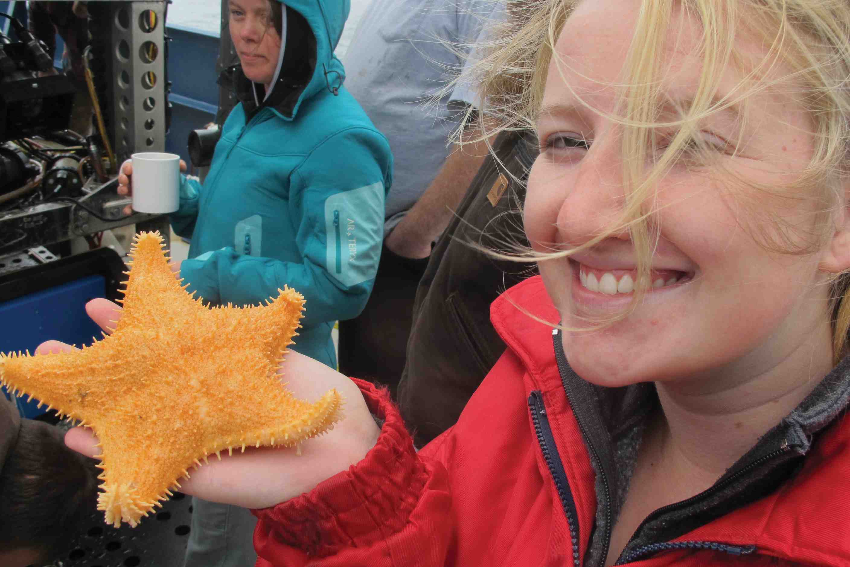
Marine life provided rich experiences for first-time sailors on Atlantis.
The weather was no less memorable, if not always pleasant.
The first Saturday was gorgeous: blue skies, a beaming sun and a placid Pacific. Student researchers who had been logging long hours in front of computer screens took the opportunity to sunbathe, read on the ship’s bow and even engage in an impromptu squirt-gun fight.
But high winds and heavy seas were the story of the trip. Winds reached fifty miles an hour, generating ocean swells of twelve feet and sentencing the Atlantis to a relentless, disorienting rise-and-fall motion that had even seasoned sailors grumbling. For some members of the research team, seasickness was an ongoing concern best managed with fresh air and a focus on the horizon—or by riding out the worst of it while tucked into bed.
Bad wind and waves also made the mission challenging: Tasked with recovering thirty instruments between Astoria, Oregon, and Cape Mendocino, California, Livelybrooks and cochief scientist Anne Trehu of Oregon State University repeatedly reset the ship’s course, seeking windows of opportunity where the weather would subside long enough to allow a team to safely deploy the ROV.
Joystick Driven
During these dives, a team of three working in a control room on the ship guided the ROV’s movements with a joystick, sending it as deep as 7,800 feet in search of instruments that had been recording vibrations of the ocean floor for more than a year. With Jason’s cameras delivering its “view” back to screens in the control room, pilots could move the ROV straight to the devices while observers were treated to rare looks at the ocean floor and marine life.
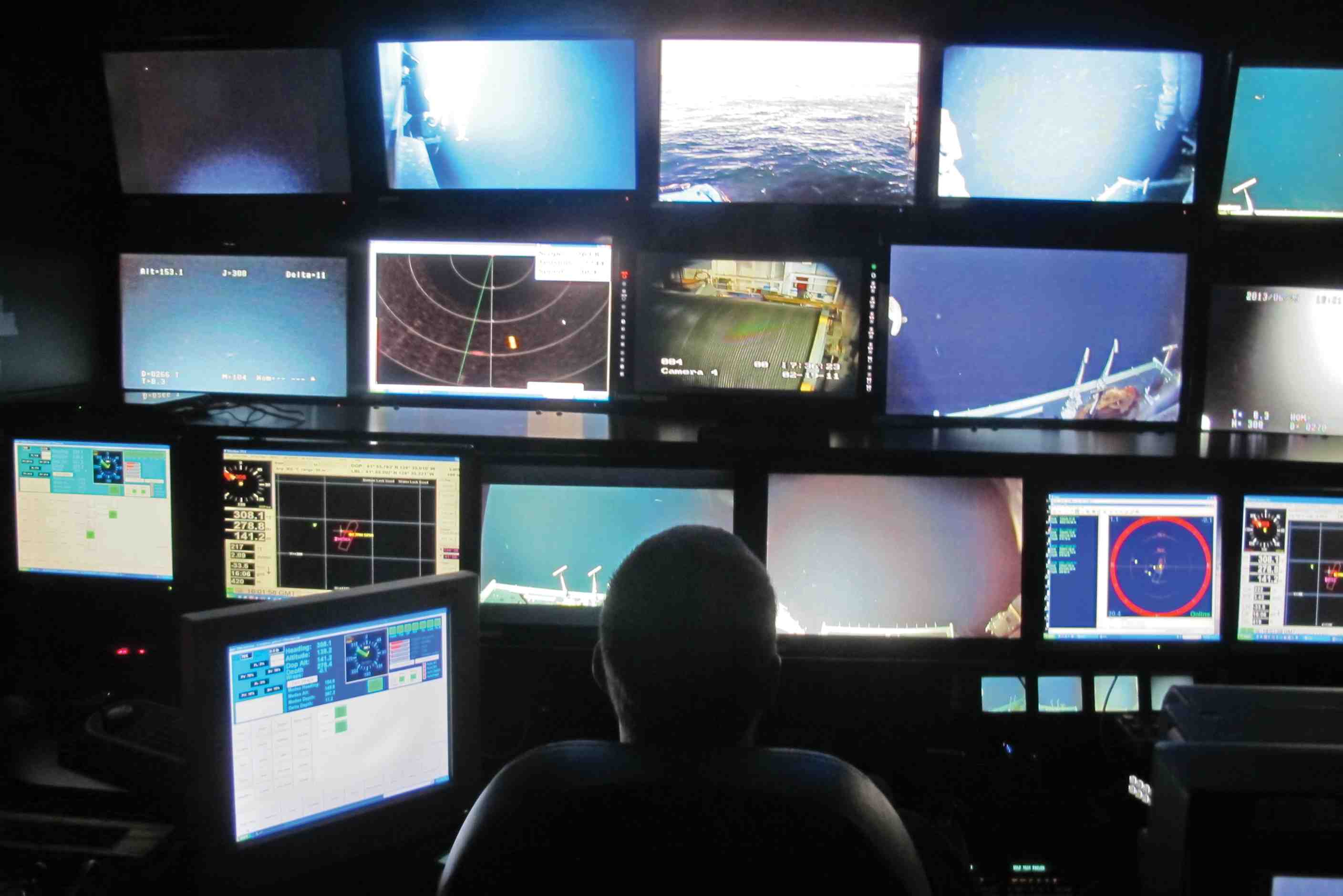
A team of three in a control room on the ship guided the ROV as deep as 7,800 feet in search of instruments that had been recording ocean-floor vibrations for more than a year.
Upon finding a seismometer, the team would send Jason to collect a device just dropped into that area from the ship—a refrigerator-sized “elevator” used to recover the instrument. After the ROV had attached a line from the elevator to the seismometer, a signal from the ship would send the buoyant elevator hurtling to the surface, where the other end of the line was attached to a crane that would then lift the 1,600-pound seismometer onboard.
It was like an elaborate video game played with equipment costing millions of dollars: Using the joystick, the pilot had to manipulate Jason’s huge mechanical arms and pincer-like grapplers to attach a chain to the seismometer and fasten it by screwing a bolt into a shackle. “Like threading a needle with boxing gloves on,” as one person described it.
A demanding operation under the best of conditions, Jason dives were off the table when the seas were rough and the deck crew and the equipment were at risk. That said, the research team recovered all thirty seismometers.
“Jason to the rescue!” Livelybrooks exclaimed after one particularly challenging recovery. “These guys are total pros, I tell you.”
Data Freely Available
The use of data in the earthquake project promises to be as interesting as the efforts taken to collect it.
Most research projects are dog-eat-dog. Scientists are inclined to withhold the information they collect for a year or more, lest someone beat them to a breakthrough and publish findings in this intensely competitive environment.
But the Cascadia Initiative is different.
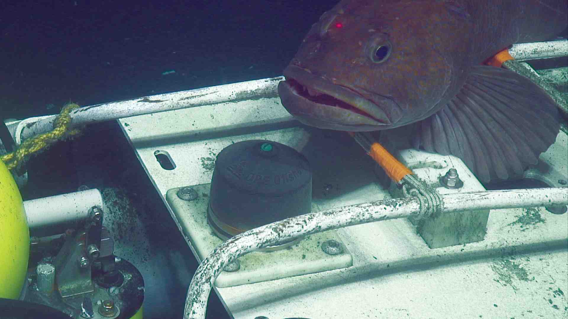
A lingcod appears to guard the trawl-resistant mound covering an ocean-bottom seismometer.
Recordings of vibrations collected from the instruments are made quickly and freely available on the Internet (once they have been scrubbed by the U.S. Navy to protect submarine movements). The project was developed as a true community experiment—serving anyone who wants to use the data—which was imperative in securing the public dollars necessary to carry it out.
The project combines the collection of onshore and offshore data. Using monitors based along the shoreline, scientists will be able to study large earthquakes and almost imperceptibly small ones in real time. Meanwhile, data from ocean-bottom seismometers will, for the first time, provide scientists with images of the physical properties of the tectonic plates offshore that are being slowly forced under the continent.
That data will be used to develop a three-dimensional model of the Cascadia subduction zone, to depths of several hundred miles. It’s like taking an MRI of the vast, unstable ocean floor between Canada and California—using seismic waves instead of radio waves—and nothing like it has ever been done before.
With a better picture of the subduction zone, officials will have more information to evaluate risk and assist mitigation efforts such as building-code standards and evacuation routes.
The Earth’s Hum
But geophysicists aren’t the only ones who benefit from the results. The data will serve researchers studying topics ranging from earthquakes, tsunamis and landslides to seafloor processes and the behavior of marine mammals.
Because the instruments are equipped with devices called “absolute pressure gauges,” Doug Luther, an oceanography professor at the University of Hawaii, will be able to analyze rare data on pressure variations at the bottom of the ocean.
UO geophysicist Dean Livelybrooks was on board to mentor community college students.
That will aid in the understanding of phenomena such as “infragravity waves” and the flow of cold water and nutrients across the continental slope. Infragravity waves, which differ from normal oceanic waves because they aren’t created by wind acting on the surface of the sea, generate seismic tremors described by scientists as “the earth’s hum”; the flow of cold water and nutrients plays important roles for local fisheries and climate variability.
“When the Cascadia Initiative was first being discussed, I was just bouncing out of my seat,” Luther said, when he realized,“You could use this for oceanography, too!”
Kelin Wang, a research scientist who develops computer models of earthquake systems for the Geological Survey of Canada, said the project will enable him to look deeper into the earth’s crust than ever before. “When you a have a large enough network of instruments, it’s like a telescope looking into the ground,” he said. “You see better.”
The data will even contribute to an understanding of some of the world’s largest mammals: endangered blue and fin whales.
Both whales call in frequencies recorded by the seismometers. William Wilcock, professor and associate director with the School of Oceanography at the University of Washington, will use that information to study whale migration patterns and other behaviors.
A fin whale could easily cross an ocean for a meal—following one, therefore, is no small task. “The neat thing about the Cascadia Initiative,” Wilcock said, “is that it covers an area of about 1,000 kilometers along the coast and 300 or 400 kilometers off the shore. We’ll be in a much better position to see migratory patterns and where the whales are when they’re calling. You can potentially monitor a single whale for days.”
The Navy is expected to take an interest in funding such research, given its obligation to consider how its operations affect—and are affected by—whale movements.
Said Wilcock: “When you get these big data sets, you can do stuff with them that you haven’t imagined.”
— Matt Cooper
Photos from Jason, courtesy of NSF, ONR, Oregon State University/Anne Trehu, University of Oregon/Dean Livelybrooks/ROV Jason 2013 ©Woods Hole Oceanographic Institution. All other photos: Matt Cooper